
high quality services in carbonate geology for the E&P industry
basin studies
noun |ˈstʌd.i | ˈstʌd.i |
"the activity of examining a basin in detail in order to discover new information"
the ability to assess the petroleum potential of an area relies on the knowledge of its geology

Our basin studies are key tools to evaluate the presence of hydrocarbon resources in the Mediterranean
The geological knowledge of an area is crucial for any exploration project and its understanding is important to evaluate the presence and effectiveness of petroleum system elements.
Our basin studies integrate publicly available subsurface and surface data and, when available, original data of which STRATA is proprietary, and provide geological syntheses of a region and studies focused on specific topics.
Geological syntheses provide an in-depth geological knowledge of an area through the definition of the structural setting, construction of GDE maps with facies distribution, reconstruction of the tectono-stratigraphic evolution, sequence stratigraphy interpretation of the basin fill, and explore the presence of potential reservoirs, traps, source rocks and seals.
Specific topics provide a complete and thorough understanding of the issues associated to specific topics related to petroleum system elements, with a regional perspective.
Our basin studies can be organised to fulfill customer's requirements in different areas of the Mediterranean, depending upon Client's requirements, and will be based on our experience in combining geo-science and the needs of a modern E&P company.
Typically, our basin studies include:
-
a comprehensive text document
-
a suite of enclosures, including maps and public available subsurface data
-
a GIS project
Some basin studies can be combined with field seminars
Please, contact us at info@stratageoresearch.com if you need more information.
EGYPT BID ROUND 2022-2023
New!
Year 2022 has been extremely successful for exploration in the East Mediterranean. Several discoveries like Chronos, Zeus and Glaucus have confirmed the interest in carbonate reservoir target and Oil Companies are now focusing the Egyptian bid round 2023. Deadline for bidding on 12 new blocks, 6 onshore and 6 offshore, is on April 2023. The new edition of our ICPs Report will improve the knowledge of carbonate petroleum systems across the Mediterranean – from Italy to Turkey, from Tunisia to Syria, from Egypt to Cyprus. We have also planned to customize brief multi-client summary reports for oil companies interested in the 2023 Egyptian bid round

(see figure for further details) in Nile Delta, and Herodotus and Levantine basins new ventures.
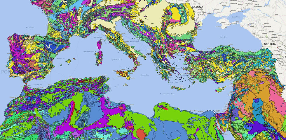
Mediterranean is a vast geological province with a common geological history related to the opening and closure of Tethys. We strongly believe that surface and subsurface data and insights from one part of this mega-basin can help constrain interpretation problems in other parts of the basin.
Our team includes experts in the regional geology of the Mediterranean, basin analysis and sequence stratigraphy, carbonate and clastic sedimentology, petroleum systems analysis and prospect evaluation, seismic interpretation, structural geology and biostratigraphy. Specific products we have developed include:
-
A mega-sequence stratigraphic framework tied to plate tectonic driving forces that provides a framework for correlation between Adria and the North Africa/ Arabian passive margins together with a suite of original paleogeographic maps
-
A review of 26 proven carbonate-hosted petroleum systems, together with detailed syntheses and original classifications of each petroleum systems’ element (reservoir, source, seal, migration and trap)
2021 version of the video-demonstration of Strata's GeoMed-GIS database.
-
A review of isolated carbonate platforms in the Mediterranean based on 130 documented examples, including a review of the seismic characteristics of these highly prospective features, and a comprehensive review of the 9 different carbonate factories that characterize the Tethyan basin fill
-
Our proprietary GeoMed-GIS that covers the central and eastern Mediterranean and includes a large amount of georeferenced surface and subsurface geological data, described in terms of Strata’s proprietary megasequence framework and classification schemes for carbonate platform systems and petroleum systems elements (see demonstration video above for further details).
If you’re working on the Egypt bid round or exploring elsewhere in the Eastern Mediterranean, we’d love to tell you how we can help you #FocusYourResources, through our multi-client, consulting and training services.
Please contact us at info@stratageoresearch.com
ISOLATED CARBONATE PLATFORMS OF MEDITERRANEAN: GEOLOGICAL FEATURES AND HYDROCARBON POTENTIAL

The recent giant gas discovery within the Levantine basin has revitalized the interest on isolated carbonate platforms (ICP) as potential reservoirs in the Mediterranean.
This report introduces a classification of the Mediterranean ICPs, based on a large database of surface and subsurface data.
The proposed classification combines a series of tectono-stratigraphic and sedimentological features of ICPs, with their hydrocarbon potential.
The types of ICPs, their geological characteristics, such as spatial and temporal distribution, architectures and facies depositional models are examined through a regional database.
The petroleum system elements, associated with the different types of ICPs, are presented and discussed through a series of case studies of proven petroleum systems.
CARBMED-GIS PROJECT
A valid and smart tool for evaluating the exploration potential of Mediterranean Isolated Carbonate Platforms (MICPs), through the comparison of subsurface case histories and the identification of more appropriate analogues.
A GEO-DATABASE developed from public, available data, on Mediterranen Carbonates, aimed to summarize and query:
-
Scientific papers and E&P reports;
-
Available geological-data, such as:
-
Stratigraphic logs;
-
Wells;
-
Geological sections;
-
Seismic lines;
-
Geological and thematic maps;
-
HC field maps.
-
-
Distribution of ICPs in the Mediterranean, outcropping or in subsurface;
-
Main geological features of MegaSequences and their geographical distribution;
-
Information on MICPs Pet System elements

Performed with QGIS, it provides:
-
A single working environment, assembling subsurface and outcropping data
-
Integrated description of detailed lithological and stratigraphic information and petroleum system elements
-
Geological information arranged into a Megasequence Stratigraphic Framework, which attempts to unify different geological regions from Alpine Tethys to Eastern Mediterranean
-
Ability to easily query and plot data in multilayered thematic maps for each of the nine Megasequences (9 time-slices)
-
Support in the construction of play fairway and uncertainties maps
-
An interactive database structure which could integrate other datasets or be used in other contexts
MESO-CENOZOIC TETHYAN MEGASEQUENCES CHART
An original, unique regional megasequence stratigraphic framework attempting to unify the Alpine Tethys and Neotethys with North Africa and Eastern Mediterranean.
Developed from public, available data.

A practical synoptic chart illustrating time-space distribution and characteristics of:
-
> 70 Isolated Carbonate Platforms (ICPs)
-
> 120 formations with source potential
-
> 50 reservoirs across the Mediterranean
It provides:
-
an exploration and first-order correlation tool for the space and time distribution of Mesozoic and Cenozoic Isolated Carbonate Platforms, and associated petroleum systems across the entire Mediterranean
-
a better understanding of the relationship of Petroleum System Elements and the tectono-stratigraphic development of Isolated Carbonate Platforms
-
a contribution to better evaluate the exploration potential of Isolated Carbonate Platforms in specific areas, through the comparison of subsurface case histories and the identification of more appropriate analogues